Alex Zvoleff
Alex Zvoleff
Yeah this is annoying. And unfortunately getting this to work consistently is more complicated than it seems - the GeoTIFF standard doesn't include band names, so they aren't uniformly supported...
Sure, we can add it - we just need to remember those names may or may not show up reliably for users if we are just adding them through the...
This could be a solution: https://en.wikipedia.org/wiki/Styled_Layer_Descriptor. Do you happen to know if those are supported in ArcGIS?
And if that file type would work it would be awesome, since we could also share styling information across QGIS and Arc, and do away with the hacky JSON files...
Hmm, looks like using that file type could work. But we couldn't have all the styles in one style file given we have multiple raster layers stored within a single...
Also see #217.
The GUIs that come up for the bottom 3 options on this button (Import custom Productivity dataset, Import custom Land Cover dataset, and Import custom Soil Organic Carbon dataset) 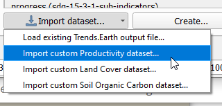...
This shouldn't be the case in many places anymore at this point, but @gdaldegan can you check the code under gee/? Wherever a dataset name is hardcoded we should be...
That's not good... will look into it.
@gdaldegan @MLNoon - is this still an issue?