Alan D. Snow
Alan D. Snow
When there are multiple bands, the `band_tags` key can be added as a list of dicts.
Please provide a simple reproducible example. Thanks!
The nodata value needs to be consistent if you want to write it to a raster. That means it needs to be `None` or `NaN` for all bands. However, in...
Related to #58. Longitudes for the data and clipping geometry need to be from [-180, 180].
> If I use a clipping geometry with the same latitude at all points, then the clipping function throws an error even though the polygon is a box rather than...
`rio.clip_box` is a workaround if you don't mind the data not being a valid raster.
> I would argue that a line that circles the globe does enclose an area. The question is, which part does it include? The top or the bottom? How would...
> How does the software currently decide what is the inside and outside of a polygon drawn on the Earth's surface? I don't see how drawing a circle along a...
> I still don't fully understand why the clipping doesn't work for the geometry in my first example. EPSG: 4326 goes from -180 to 180 in the longitude range. You...
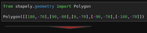
The clipping polygon in Example 3 doesn't appear to be what you are wanting it to be: