ericemc3
ericemc3

The doc states: > "When working with multiple polygon and polyline layers, the -simplify command is applied to all of the layers." But why is that? It can prove useful...
Here is a simplified use case: 2 layers, i simplify and filter the first one, then merge both. And i get a bunch of red dots, many line intersections are...
I select a polygon in a layer (via Select features) then click the Split button. I am getting 2 layers named '1' and '2' 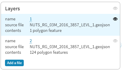 But it is not consistent...
allowing for instance to create, after clipping with it another layer, something like this: 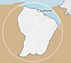
I love the possibility to call mapshaper.org with the `file` parameter, allowing for instance: https://mapshaper.org/?files=https://.../mylayer.geojson;https://.../mydata.csv Would it be possible to add a script file, containing mapshaper command to run after...
It is a feature request, considering the unique topological decomposition process which is at the center of mapshaper. Such as the `this.partCount` property, would it be possible to add (after...
it looks like -mosaic, applied to a dissolved layer, takes into account the initial layer Here is a reprex: https://mapshaper.org/?files=https://gisco-services.ec.europa.eu/distribution/v2/nuts/geojson/NUTS_RG_60M_2016_3857_LEVL_1.geojson `-mosaic -info` => 211 records https://mapshaper.org/?files=https://gisco-services.ec.europa.eu/distribution/v2/nuts/geojson/NUTS_RG_60M_2016_3857_LEVL_1.geojson `-dissolve CNTR_CODE + name=cntr...
I have loaded 2 shapefiles and, willing to add a third one, i can't, clicking the Add file button does not yield anything: 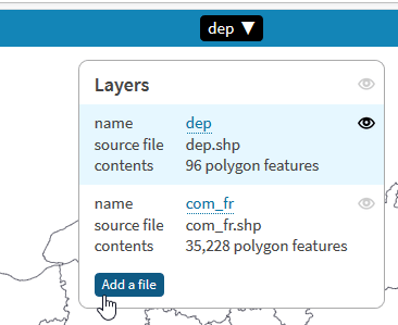
the doc states: "Remove small detached polygon rings (islands)". i am still confused with how it works: i am expecting it to apply filter on multipolygons only and remove external...
An extension to op.ntile() could prove useful to encode numeric values to categories from manual breaks. Something similar to the R `cut `function: `dens_code = cut( pop_density, breaks = c(0,...