OpenTopoMap
 OpenTopoMap copied to clipboard
A topographic map from OpenStreetMap and SRTM data

Sorry if this is wrong here, but i found no error in the openstreetmap data. Perhaps it is a error in the topo-data? [https://opentopomap.org/#map=16/46.77517/12.80718](https://opentopomap.org/#map=16/46.77517/12.80718) 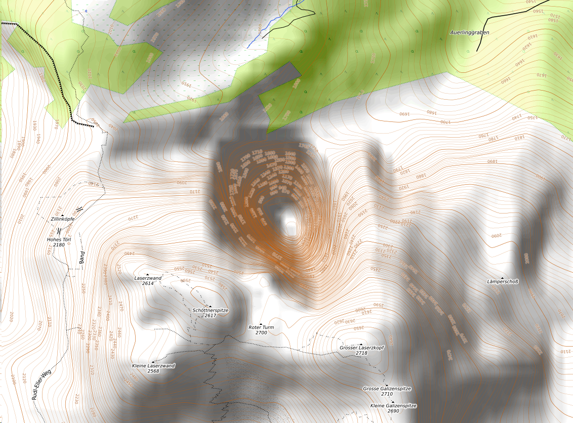
At the top of the maps is `Garmin | About | Credits` Everything is fine when we click on "Garmin," but when we click on [About](https://www.opentopomap.org/about) it is in _some...
For many place nodes, population is no longer entered. Instead, the node is entered as admin_centre of a relation and the important information is located there. We should consider relations...
According to https://taginfo.openstreetmap.org/tags/?key=amenity&value=hunting_stand#projects OpenTopoMap shows amenity=hunting_stand but doesn't. Please add this feature.
When I searched for Brilon (a town in Germany) on https://opentopomap.org/#map=10/51.3962/8.5680 I found three entries starting with Brilon but two of them are butchers: https://opentopomap.org/#map=10/51.5703/9.2394 https://opentopomap.org/#map=10/51.5749/9.2436 On OpenStreetMap this is...
Check this very famous and popular place at Obersee (right next to Königssee) in Berchtesgadener Land: https://opentopomap.org/#map=16/47.51641/12.98895 Contour lines seem to be completely messed up resp. incorrectly calculated. I really...
I wonder, which setting were used to generate `$DATA_DIR/dem/contours/contours-$continent.pbf`? Is it SRTM1 or SRTM3 or VIEW data? Which step and simplifying options were used? I cannot find options which was...
A quite common drawing technique used by mappers is to split up large forest landcovers in several polygons, where the seamline doesn't actually mean anything in the real world. The...
I have recently noticed that POI names (for example parks, shops, gas stations) are rendered as "Operator: Name" in the Garmin map. This leads to POI names list that is...
https://www.naviboard.de/thread/60127-76cs-probleme-bei-open-topo-karten%C3%BCbertragung/?postID=493553&highlight=opentopomap#post493553
Metadata
Owner
Metadata
A topographic map from OpenStreetMap and SRTM data