ODIN
 ODIN copied to clipboard
Open Source C2IS (Command and Control Information System)

The properties of the symbols for sea surface symbols should be improved, since not all amplifiers can be filled in according to 2525c or 2525d:  Proposal for the content...
The properties of the symbols for installations (land symbols) should be improved, since not all amplifiers can be filled in according to 2525c or 2525d:  Remarks: The ampfliers marked...
The properties of the symbols for equipment (land symbols) should be improved, since not all amplifiers can be filled in according to 2525c or 2525d: 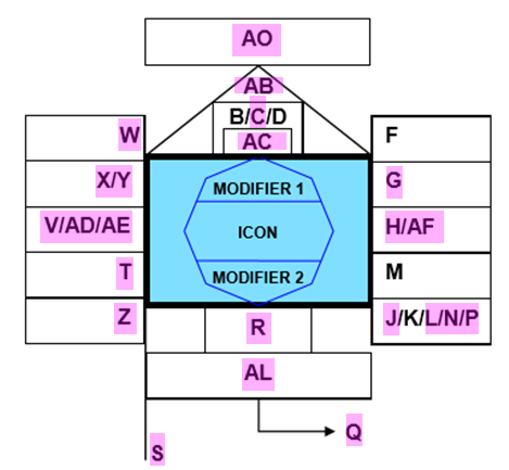 Remarks: The ampfliers marked...
The properties of the symbols for units (land symbols) should be improved, since not all amplifiers can be filled in according to 2525c or 2525d:  Remarks: The ampfliers marked...
The properties of the air symbols should be improved, since not all amplifiers can be filled in according to 2525c or 2525d: Ampflifiers concerning 2525d:  Proposal for the content...
The properties of the space symbols should be improved, since not all amplifiers can be filled in according to 2525c or 2525d: Ampflifiers concerning 2525d:  Proposal for the content...
The properties of the symbols for sea subsurface symbols should be improved, since not all amplifiers can be filled in according to 2525c or 2525d:  Proposal for the content...
When drawing symbols on a map users often switch between different centers and zoom levels. I'll call the tuple of center and zoom level a 'bookmark'. In order to return...
OpenLayers uses [proj4js](https://github.com/proj4js/proj4js) to re-project sources to the current view. Since we can't include every projection definition we should provide an easy way to do so. [epsg.io](http://epsg.io) provides frequently used...
Based on the given URL ODIN tries to detect the type of the tile provider (XYZ or WMTS). Since this detection may fail in some cases we need to allow...