osrm
 osrm copied to clipboard
Interface between R and the OpenStreetMap-based routing service OSRM
osrm 
![]()
![]()

Interface Between R and the OpenStreetMap-Based Routing Service OSRM
Description
OSRM is a routing service based on OpenStreetMap data. See http://project-osrm.org/ for more information. This package allows to compute routes, trips, isochrones and travel distances matrices (travel time and kilometric distance).
This package relies on the usage of a running OSRM service (tested with v5.26.0 of OSRM).
You can run your own instance of OSRM following guidelines provided here. The simplest solution is probably the one based on docker containers.
:warning: You must be careful using the OSRM demo server and read the
about page of the
service:
> One request per second max. No scraping, no heavy
usage.
Features
-
osrmTableGet travel time matrices between points. -
osrmRouteGet the shortest path between two points. -
osrmTripGet the travel geometry between multiple unordered points. -
osrmIsochroneGet polygons of isochrones.
Demo
osrmTable()
library(osrm)
library(sf)
apotheke.sf <- st_read(system.file("gpkg/apotheke.gpkg", package = "osrm"),
                       quiet = TRUE)
# Travel time matrix
distA <- osrmTable(loc = apotheke.sf[1:5,])
distA$durations
| 1 | 2 | 3 | 4 | 5 | |
|---|---|---|---|---|---|
| 1 | 0.0 | 21.1 | 33.4 | 21.2 | 12.6 |
| 2 | 22.1 | 0.0 | 42.3 | 16.1 | 20.2 |
| 3 | 33.0 | 43.0 | 0.0 | 30.5 | 27.4 |
| 4 | 20.1 | 15.3 | 29.7 | 0.0 | 12.7 |
| 5 | 10.2 | 20.3 | 26.8 | 12.3 | 0.0 |
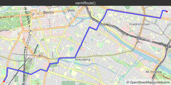
osrmRoute()
library(maptiles)
library(mapsf)
# Transform to webmercator for a better display of map tiles
apotheke.sf <- st_transform(apotheke.sf, 3857)
# Route
route <- osrmRoute(src = apotheke.sf[74,], dst = apotheke.sf[55,],
                   overview = "full")
# Get map tiles
osm <- get_tiles(x = route, crop = TRUE, zoom = 13)
# Map
theme <- mf_theme(mar = c(0,0,1.2,0), inner = FALSE, line = 1.2, cex = .9,
                  pos = "center", tab = FALSE)
mf_export(osm,filename = "img/route.png", width = ncol(osm), theme = theme)
mf_raster(osm, add = TRUE)
mf_map(route, lwd = 4, add = TRUE, col = "blue")
mf_map(route, lwd = 1, col = "white", add = TRUE)
mf_map(apotheke.sf[c(74,55),], pch = 20, col = "red", add = TRUE)
mf_title("osrmRoute()")
mf_credits(get_credit("OpenStreetMap"), pos = "bottomright", cex = .8,
           bg = "#ffffff80")
dev.off()
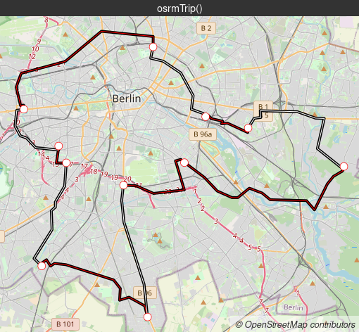
osrmTrip()
# Trip
trips <- osrmTrip(loc = apotheke.sf[10:20,])
trip <- trips[[1]]$trip
# Get map tiles
osm2 <- get_tiles(x = trip, crop = TRUE, zoom = 11)
# Map
mf_export(osm2,filename = "img/trip.png", width = ncol(osm2), theme = theme)
mf_raster(osm2, add = TRUE)
mf_map(trip, col = "black", lwd = 4, add = TRUE )
mf_map(trip, col = c("red", "white"), lwd = 1, add = TRUE)
mf_map(apotheke.sf[10:20,], pch = 21, col = "red", cex = 1.5, add = TRUE)
mf_title("osrmTrip()")
mf_credits(get_credit("OpenStreetMap"), pos = "bottomright", cex = .8,
           bg = "#ffffff80")
dev.off()
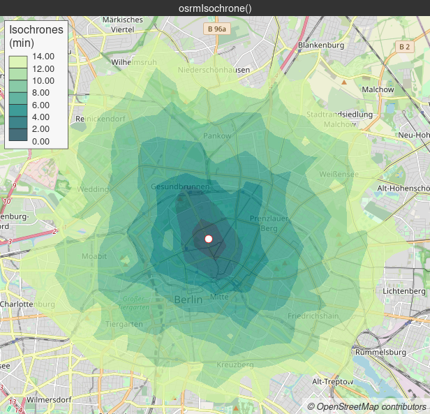
osrmIsochrone()
bks <- seq(from = 0, to = 14, by = 2)
iso <- osrmIsochrone(loc = apotheke.sf[87,], breaks = bks, res = 70)
# Get map tiles
osm3 <- get_tiles(x = iso, crop = TRUE, zoom = 12)
# Map
cols <- hcl.colors(n = 7, palette = "Emrld", alpha = 0.75, rev = F)
mf_export(osm3,filename = "img/iso.png", width = ncol(osm3), theme = theme)
mf_raster(osm3, add = TRUE)
mf_map(x = iso, var = "center", type = "choro",
       breaks = bks, border = NA, pal = cols,
       leg_pos = "topleft", leg_frame = T,
       leg_title = "Isochrones\n(min)",
       leg_title_cex = 1, leg_val_cex = .8,
       add = TRUE)
mf_map(apotheke.sf[87,], pch = 21, col = "red",
       cex = 1.5, add=TRUE)
mf_title("osrmIsochrone()")
mf_credits(get_credit("OpenStreetMap"), pos = "bottomright", cex = .8,
           bg = "#ffffff80")
dev.off()
Installation
- Development version on GitHub
remotes::install_github("riatelab/osrm")
- Stable version on CRAN
install.packages("osrm")
Community Guidelines
One can contribute to the package through pull requests and report issues or ask questions here.