sf
 sf copied to clipboard
Buffering by negative value returns empty polygon
Buffering by negative value returns empty polygon. I think, but not entirely sure, this was not the case before.
To Reproduce
library(sf)
#> Linking to GEOS 3.8.0, GDAL 3.0.4, PROJ 6.3.1; sf_use_s2() is TRUE
bbox <- st_bbox(c(xmin = 16.1, xmax = 16.6, ymax = 48.6, ymin = 47.9), crs = st_crs(4326))
st_buffer(st_as_sfc(bbox), -5)
#> Geometry set for 1 feature  (with 1 geometry empty)
#> Geometry type: POLYGON
#> Dimension:     XY
#> Bounding box:  xmin: NA ymin: NA xmax: NA ymax: NA
#> Geodetic CRS:  WGS 84
#> POLYGON EMPTY
st_bbox(st_buffer(st_as_sfc(bbox), -5))
#> xmin ymin xmax ymax
#>   NA   NA   NA   NA
st_buffer(st_as_sfc(bbox), 5)
#> Geometry set for 1 feature
#> Geometry type: POLYGON
#> Dimension:     XY
#> Bounding box:  xmin: 16.092 ymin: 47.89505 xmax: 16.6081 ymax: 48.60544
#> Geodetic CRS:  WGS 84
#> POLYGON ((16.12336 47.89515, 16.12608 47.89983,...
st_bbox(st_buffer(st_as_sfc(bbox), 5))
#>     xmin     ymin     xmax     ymax
#> 16.09200 47.89505 16.60810 48.60544
Created on 2022-08-17 with reprex v2.0.2
sessionInfo()
R version 4.2.1 (2022-06-23)
Platform: x86_64-pc-linux-gnu (64-bit)
Running under: Ubuntu 20.04.4 LTS

Matrix products: default
BLAS:   /usr/lib/x86_64-linux-gnu/blas/libblas.so.3.9.0
LAPACK: /usr/lib/x86_64-linux-gnu/lapack/liblapack.so.3.9.0

locale:
 [1] LC_CTYPE=C.UTF-8       LC_NUMERIC=C           LC_TIME=C.UTF-8        LC_COLLATE=C.UTF-8     LC_MONETARY=C.UTF-8
 [6] LC_MESSAGES=C.UTF-8    LC_PAPER=C.UTF-8       LC_NAME=C              LC_ADDRESS=C           LC_TELEPHONE=C
[11] LC_MEASUREMENT=C.UTF-8 LC_IDENTIFICATION=C

attached base packages:
[1] stats     graphics  grDevices datasets  utils     methods   base

other attached packages:
 [1] reprex_2.0.2    sf_1.0-8        forcats_0.5.1   stringr_1.4.0   dplyr_1.0.9     purrr_0.3.4     readr_2.1.2
 [8] tidyr_1.2.0     tibble_3.1.8    ggplot2_3.3.6   tidyverse_1.3.2

loaded via a namespace (and not attached):
 [1] httr_1.4.3          jsonlite_1.8.0      modelr_0.1.8        assertthat_0.2.1    sp_1.5-0
 [6] highr_0.9           renv_0.15.5         googlesheets4_1.0.0 cellranger_1.1.0    yaml_2.3.5
[11] pillar_1.8.0        backports_1.4.1     lattice_0.20-45     glue_1.6.2          digest_0.6.29
[16] rvest_1.0.2         colorspace_2.0-3    htmltools_0.5.3     pkgconfig_2.0.3     broom_1.0.0
[21] raster_3.5-29       haven_2.5.0         stars_0.5-6         s2_1.1.0            scales_1.2.0
[26] processx_3.7.0      terra_1.6-7         tzdb_0.3.0          proxy_0.4-27        googledrive_2.0.0
[31] generics_0.1.3      ellipsis_0.3.2      withr_2.5.0         cli_3.3.0           magrittr_2.0.3
[36] crayon_1.5.1        readxl_1.4.0        ps_1.7.1            evaluate_0.16       fs_1.5.2
[41] fansi_1.0.3         xml2_1.3.3          lwgeom_0.2-8        class_7.3-20        tools_4.2.1
[46] hms_1.1.1           gargle_1.2.0        lifecycle_1.0.1     munsell_0.5.0       callr_3.7.1
[51] compiler_4.2.1      e1071_1.7-11        RNetCDF_2.6-1       rlang_1.0.4         classInt_0.4-7
[56] units_0.8-0         grid_4.2.1          rstudioapi_0.13     rmarkdown_2.14      wk_0.6.0
[61] gtable_0.3.0        codetools_0.2-18    abind_1.4-5         DBI_1.1.3           R6_2.5.1
[66] ncmeta_0.3.0        lubridate_1.8.0     knitr_1.39          fastmap_1.1.0       utf8_1.2.2
[71] KernSmooth_2.23-20  stringi_1.7.8       parallel_4.2.1      Rcpp_1.0.9          vctrs_0.4.1
[76] dbplyr_2.2.1        tidyselect_1.1.2    xfun_0.31
What was returned before, and before what or when? If anything this would be a change in GEOS, which maybe returned a GEOMETRYCOLLECTION EMPTY before?
I worked on it a few months ago, but I've changed machines since and unfortunately can't tell anymore what version of sf or GEOS I had installed. If I recall correctly, it returned a POLYGON, but I merely used it as a quick way to get a shrunken bbox, which now doesn't work anymore either.
Regardless, I would expect a negative buffer to shrink polygons, but all polygons become empty if I do now. But maybe my assumption is incorrect. See below:
library(sf)
#> Linking to GEOS 3.8.0, GDAL 3.0.4, PROJ 6.3.1; sf_use_s2() is TRUE
library(units)
#> udunits database from /usr/share/xml/udunits/udunits2.xml
nc_sf <- st_read(system.file("shape/nc.shp", package="sf"), quiet=TRUE)
plot(nc_sf["AREA"])

st_buffer(nc_sf["AREA"], set_units(0.05, degree))
#> Simple feature collection with 100 features and 1 field
#> Geometry type: MULTIPOLYGON
#> Dimension:     XY
#> Bounding box:  xmin: -84.38574 ymin: 33.82673 xmax: -75.38785 ymax: 36.64189
#> Geodetic CRS:  NAD27
#> First 10 features:
#>     AREA                       geometry
#> 1  0.114 MULTIPOLYGON (((-81.21884 3...
#> 2  0.061 MULTIPOLYGON (((-80.86545 3...
#> 3  0.143 MULTIPOLYGON (((-80.7824 36...
#> 4  0.070 MULTIPOLYGON (((-75.80691 3...
#> 5  0.153 MULTIPOLYGON (((-77.21177 3...
#> 6  0.097 MULTIPOLYGON (((-77.19596 3...
#> 7  0.062 MULTIPOLYGON (((-76.15519 3...
#> 8  0.091 MULTIPOLYGON (((-76.44185 3...
#> 9  0.118 MULTIPOLYGON (((-77.92781 3...
#> 10 0.124 MULTIPOLYGON (((-80.50494 3...
plot(st_buffer(nc_sf["AREA"], set_units(0.05, degree)))

st_buffer(nc_sf["AREA"], set_units(-0.05, degree))
#> Simple feature collection with 100 features and 1 field (with 100 geometries empty)
#> Geometry type: POLYGON
#> Dimension:     XY
#> Bounding box:  xmin: NA ymin: NA xmax: NA ymax: NA
#> Geodetic CRS:  NAD27
#> First 10 features:
#>     AREA      geometry
#> 1  0.114 POLYGON EMPTY
#> 2  0.061 POLYGON EMPTY
#> 3  0.143 POLYGON EMPTY
#> 4  0.070 POLYGON EMPTY
#> 5  0.153 POLYGON EMPTY
#> 6  0.097 POLYGON EMPTY
#> 7  0.062 POLYGON EMPTY
#> 8  0.091 POLYGON EMPTY
#> 9  0.118 POLYGON EMPTY
#> 10 0.124 POLYGON EMPTY
plot(st_buffer(nc_sf["AREA"], set_units(-0.05, degree)))
#> Error in plot_sf(x, ...): NA value(s) in bounding box. Trying to plot empty geometries?

Created on 2022-08-17 with reprex v2.0.2
Is the outcome the same if st_use_s2() is FALSE? The input geometries are geographic not planar, so s2 may be in play.
should this issue be addressed with a documentation PR on buffer with a warning about sf_us_s2()
Hello everyone,
I am a new user and my intention basically is to create a convex hull and then create a smaller hull using st_buffer and a negative value of buffer distance. However, like in this and others posts, it always return an empty polygon.
I was checking the Simple Features for R vignette and there is this example on the Geometric operations where the st_buffer works fine with negative values and it got me by surprise. The only difference from my convex hull and the example was the projection (WGS 84 vs WGS 84 / Pseudo-Mercator), so i tried to change the projection of the example and voila, the negative value using WGS 84 returns an empty polygon.
Is that a bug?
library(sf)
nc <- st_read(system.file("shape/nc.shp", package="sf"))
nc.web.EPSG <- st_transform(nc, crs= "EPSG:4326")
sel <- c(1,5,14)
geom <- st_geometry(nc.web.EPSG[sel,])
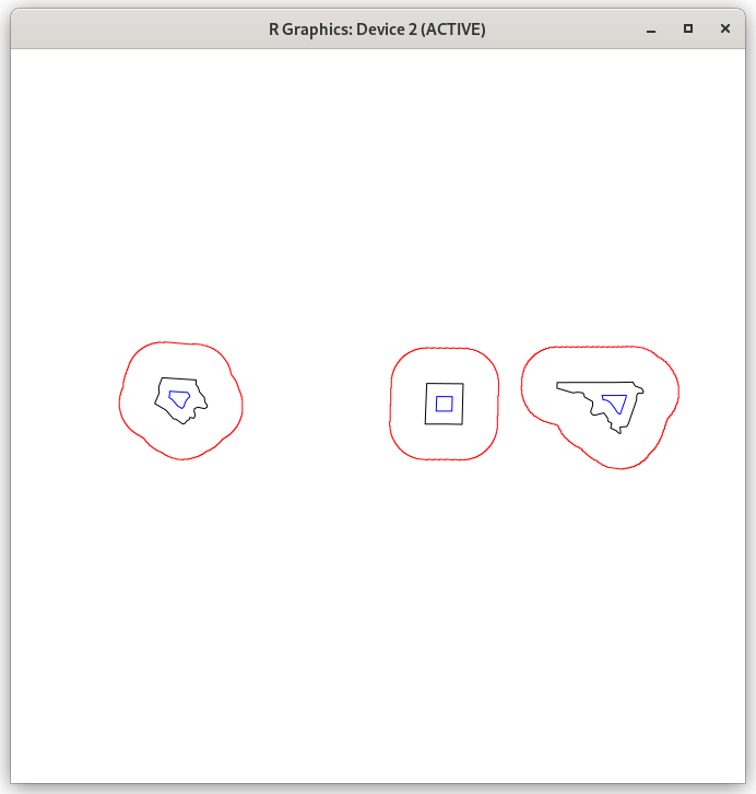
buf <- st_buffer(geom, dist = 30000)
plot(buf, border = 'red')
plot(geom, add = TRUE)
plot(st_buffer(geom, -10000), add = TRUE, border = 'blue')
#Geometry set for 3 features (with 3 geometries empty)
#Geometry type: POLYGON
#Dimension: XY
#Bounding box: xmin: NA ymin: NA xmax: NA ymax: NA
#Geodetic CRS: WGS 84
#POLYGON EMPTY
#POLYGON EMPTY
#POLYGON EMPTY
nc.web_mercator <- st_transform(nc, crs= 3857)
sel <- c(1,5,14)
geom <- st_geometry(nc.web_mercator[sel,])
buf <- st_buffer(geom, dist = 30000)
plot(buf, border = 'red')
plot(geom, add = TRUE)
plot(st_buffer(geom, -10000), add = TRUE, border = 'blue')
#Geometry set for 3 features
#Geometry type: POLYGON
#Dimension: XY
#Bounding box: xmin: -9086682 ymin: 4339742 xmax: -8596499 ymax: 4371623
#Projected CRS: WGS 84 / Pseudo-Mercator
#POLYGON ((-9074360 4347826, -9079727 4354112, -...
#POLYGON ((-8632038 4367097, -8607181 4367131, -...
#POLYGON ((-8782440 4342743, -8788570 4342863, -...
sessionInfo()
R version 4.2.1 (2022-06-23)
Platform: x86_64-pc-linux-gnu (64-bit)
Running under: Ubuntu 22.04.1 LTS

Matrix products: default
BLAS:   /usr/lib/x86_64-linux-gnu/openblas-pthread/libblas.so.3
LAPACK: /usr/lib/x86_64-linux-gnu/openblas-pthread/libopenblasp-r0.3.20.so

locale:
 [1] LC_CTYPE=pt_BR.UTF-8       LC_NUMERIC=C               LC_TIME=pt_BR.UTF-8        LC_COLLATE=pt_BR.UTF-8
 [5] LC_MONETARY=pt_BR.UTF-8    LC_MESSAGES=pt_BR.UTF-8    LC_PAPER=pt_BR.UTF-8       LC_NAME=C
 [9] LC_ADDRESS=C               LC_TELEPHONE=C             LC_MEASUREMENT=pt_BR.UTF-8 LC_IDENTIFICATION=C

attached base packages:
[1] stats     graphics  grDevices utils     datasets  methods   base

other attached packages:
[1] sf_1.0-9

loaded via a namespace (and not attached):
 [1] styler_1.8.1       gtools_3.9.3       tidyselect_1.2.0   terra_1.6-47       xfun_0.34          purrr_1.0.0
 [7] lattice_0.20-45    vctrs_0.5.1        generics_0.1.3     htmltools_0.5.3    s2_1.1.1           yaml_2.3.6
[13] utf8_1.2.2         rlang_1.0.6        R.oo_1.25.0        e1071_1.7-12       pillar_1.8.1       glue_1.6.2
[19] withr_2.5.0        DBI_1.1.3          R.utils_2.12.2     sp_1.5-1           wk_0.7.0           lifecycle_1.0.3
[25] R.cache_0.16.0     gtable_0.3.1       raster_3.6-11      R.methodsS3_1.8.2  codetools_0.2-18   evaluate_0.18
[31] knitr_1.40         callr_3.7.3        fastmap_1.1.0      ps_1.7.2           class_7.3-20       fansi_1.0.3
[37] highr_0.9          Rcpp_1.0.9         KernSmooth_2.23-20 clipr_0.8.0        classInt_0.4-8     fs_1.5.2
[43] gridExtra_2.3      digest_0.6.30      processx_3.8.0     dplyr_1.0.10       dismo_1.3-9        grid_4.2.1
[49] cli_3.4.1          tools_4.2.1        magrittr_2.0.3     proxy_0.4-27       tibble_3.1.8       pkgconfig_2.0.3
[55] reprex_2.0.2       assertthat_0.2.1   rmarkdown_2.18     rstudioapi_0.14    R6_2.5.1           units_0.8-1
[61] compiler_4.2.1
sf::sf_extSoftVersion()
          GEOS           GDAL         proj.4 GDAL_with_GEOS     USE_PROJ_H           PROJ
      "3.10.2"        "3.4.1"        "8.2.1"         "true"         "true"        "8.2.1"
Please read the comments above and https://r-spatial.org/r/2020/06/17/s2.html. Does sf_use_s2() make a difference for the non-planar case?
Please read the comments above and https://r-spatial.org/r/2020/06/17/s2.html. Does sf_use_s2() make a difference for the non-planar case?
Using sf_use_s2(FALSE) also returns empty polygons as well.
st_buffer(geom, -10000) dist is assumed to be in decimal degrees (arc_degrees). Geometry set for 3 features (with 3 geometries empty) Geometry type: POLYGON Dimension: XY Bounding box: xmin: NA ymin: NA xmax: NA ymax: NA Geodetic CRS: WGS 84 POLYGON EMPTY POLYGON EMPTY POLYGON EMPTY Warning message: In st_buffer.sfc(geom, -10000) : st_buffer does not correctly buffer longitude/latitude data
Which is as expected for a buffer of -10000 degrees, isn't it?
With sf 1.0-10 (devel) and 1.0-9 (CRAN):
sf_use_s2(FALSE)
plot(st_buffer(geom, -0.1), add = TRUE, border = 'blue')