id-tagging-schema
 id-tagging-schema copied to clipboard
Support addr:place addresses
addr:housenumber=10
addr:place=Village without street names
is a valid tagging, in widespread use, not supported by iD

When used iD encourages to add not actually missing data. Especially "City" field is a nasty trap.
Ideally it would be shown as "Address without street name" or something, at least when tagged already
https://taginfo.openstreetmap.org/keys/addr%3Aplace https://wiki.openstreetmap.org/wiki/Key%3Aaddr%3Aplace
See also https://github.com/openstreetmap/iD/issues/2898
Triggered by https://forum.openstreetmap.org/viewtopic.php?pid=851946#p851946 where user was confused by not displayed addresses
//edit @tyrasd: I've removed a part of the original title, because it was a bit long. It used to include the following information: […] (over 9 000 000 uses, widespread addressing schema, iD interface encourages to break addressing data)
There should be a drop-down menu where you can choose an address format valid for the region/BBOX. Something like:
Select an address format:
- Urban: House number, street, suburb, postcode, city
- Urban: No house number*, street, suburb, postcode, city (POI needs a name)
- Urban: Suburb/ward, cityblock, house number, postcode, city
- By milestone: Road, milestone**, postcode, city
- Minor rural settlement: House name, road, postcode, city
- Hamlet: Place, house number, postcode
- Farms: Place, postcode
* -- adds nohousenumber=yes tag.
** -- uses addr:milestone (proposed tag)
I would definitely like to improve this! It will however require a delicate approach since addresses are quite a complex matter…
Btw, I had proposed this one myself back in 2014 in https://github.com/openstreetmap/iD/pull/2246#issuecomment-45094187 :sweat_smile:
in widespread use
A warning: a lot of the use is incorrect. In the UK we worked out that at least 80% of the addr:place data was wrong. A tag like addr:suburb should have been used instead!
Nomination Data Analyser shows incorrect cases where addr:place and addr:street have been used on the same feature.
Having cleaned up a lot of the incorrect uses in the UK, and followed lengthy discussions on talk-GB, I found the following issues:
- "Place" as a word leads people to think of settlements (village, town, etc) or suburbs. What it doesn't communicate is that the addressees are grouped by the place and not by a street.
- JOSM's Address preset dialogue puts addr:place between addr: street and addr:city. There is no message in the dialogue to say that you should complete street or place but not both. This leads to people thinking addr:place is for suburbs.
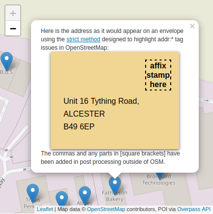
- Visualisations of the address really help. We render a map to help mappers, so why not render an addressees envelope? I've done this for the UK: https://envelopes.osmuk.org/#18/50.83292/-0.15528
addresses are quite a complex matter…
I love the use of the word "quite" in there. So polite and almost downplays the issue. Addressees are hugely complex in the style and variety across different countries. Whatever solution is build for this, it will certainly need to be adaptable depending on which country you are mapping in.
As seen in the screenshot in https://github.com/openstreetmap/id-tagging-schema/issues/353#issue-1101480704, the Address field is already capable of being laid out like a printed address on an envelope. It also varies by country. What isn’t currently supported is a mechanism for toggling between different formats relevant within a single country or conditionally showing one textbox based on another textbox being filled in. This capability would be useful regardless of addr:place in some countries like Vietnam that have distinct urban and rural address formats (and distinct mappings to OpenStreetMap tags).
JOSM's Address preset dialogue puts addr:place between addr: street and addr:city. There is no message in the dialogue to say that you should complete street or place but not both. This leads to people thinking addr:place is for suburbs.
Have you already reported this issue to JOSM developers? (or is there an open issue created by someone else?)
the Address field is already capable of being laid out like a printed address on an envelope. It also varies by country. What isn’t currently supported ...
I hadn't seen this as an envelope but I had realised the positioning was done to aid mappers. And I agree, it is all the bits that are missing that add complexity. For example in the UK one line of the address would be addr:housenumber + " " + addr:street. But if you add a addr:place tag then it becomes two lines showing addr:housenumber + " " + addr:place on one line, with addr:parentstreet on the second (yes, we have an addr:parentstreet tag in the UK because some addressees have a child+parent relationship type concept here).
Have you already reported this issue to JOSM
Yes. https://josm.openstreetmap.de/ticket/21859#ticket
What would need to be implemented in order to make this happen? The two situations I can imagine are one where you select a format for a country, or one where you can just add more fields to it like [+] Block Number and so on. I'm curious because I've noticed recently how often addresses get mapped with things that are not street names in the street name field.
It seems like something flexible that doesn't assume too much about what sort of addresses a user is mapping would be the simplest. Not everywhere even has a ruleset about what what addresses should look like, so I think options like "urban address" and "village" address could potentially complicate things when the user likely knows which fields are relevant and which aren't as long as they're all options. Otherwise you could end up trying to account for things like "gas station in the Himalayas" address (usually has a milestone address) or "houseboat address" (might have a marina name in it as addr:place) and so on.
is it possible to at least show addr:place if set ? this would avoid users filling addr:street because it is empty is it possible to issue an validator error if addr:street + addr:place ? is it possible to grey out/hide addr:postcode addr:city by country ? or retrieve the info from the encompassing relations ? this will avoid having users thinking the info is missing
is it possible to issue an validator error if addr:street + addr:place ?
Keep in mind that this is a valid combination despite the wiki. The plaque below is placed on a apartment building. It means addr:place=ж.к. Хиподрума + addr:housenumber=бл. 121 (addr:place comes from historic data and is currently used). The address on the second line is addr:street=Урвич + addr:housenumber=1.

Keep in mind that this is a valid combination despite the wiki.
This is what I used to think too but not anymore. This year we had a very long discussion with the UK community and learnt about the history of addr:place (the tag didn't originate from the UK mapping community). It is for use when there is no addr:street. So certainly in many communities the validation rule proposed should be implemented.
As for the address example above, I'm not familiar with addresses in Bulgaria. We decided to respect the original intent of addr:place and not use it with addr:street. Through discussion we came up with other solutions. Should you wish to do the same then community discussion is the way forward. Of course if the local community is aware of this and has decided to use addr:place anyway, then fine but that shouldn't stop validation checks flagging it for most other countries.
For more details see the conclusions of the UK discussion here: https://wiki.openstreetmap.org/wiki/Addresses_in_the_United_Kingdom
Of course if the local community is aware of this and has decided to use addr:place anyway, then fine but that shouldn't stop validation checks flagging it for most other countries.
I agree with you. Such cases are an exception to the rule. I think we already disscused it in the community and found some solution but I can't find the thread right now.
This double addressing system is wide-spread in areas of the former Austria-Hungarian empire. (I presume that this is what @Dimitar5555 refers to although it is hard to say without knowing where the example comes from.) It is usually tagged in OSM using addr:streetnumber + addr:street together with addr:conscriptionnumber + addr:place. It is indeed the exception where addr:street and addr:place appear together on the same address node. I'm not aware of any other exceptions.
@lonvia it's a Soviet era panel building. addr:place refers to the residential complex in which it is located. addr:streetnumber is used to represent the building number inside that complex (so you can have two addr:streetnumber=бл. 1 as long as they have different values for addr:place). This particular building also has a street number which cause that collision. The cadastral map has it registered as Residential Complex "Hipodruma", 1 Urvich St. 1, building №121...
Is there any reason for keeping this issue open? It seems like it has been resolved.