mapfish-print
 mapfish-print copied to clipboard
A component of MapFish for printing templated cartographic maps. This module is the Java serverside module.
Hi, I am using windows. I installed tomcat 8.5. Then deployed print-servlet 3.9 war. There are some example print apps. I tried to print "Simple", but it didn't build any...

Hello, I just upgraded to version 2.1.2. Printing gave following error. [ajp-nio-8009-exec-16] ERROR h.print.servlet.BaseMapServlet - Error while generating PDF java.lang.NullPointerException Removing overviewMap from config.yaml result in print working but then...
mapfish-print version: 3.14.1 Running [this example](https://gist.github.com/romanzoller/6468d78cd6c80bcabcb68f617d0cfd2f) which renders a PNG icon using the mapfish-print CLI, the following error occurs: ``` Exception in thread "main" org.apache.batik.bridge.BridgeException: null:0 The URI "data:image/png;[...]" on...
Missing documentation for buildreport.:format at "Web Protocol" description, but it work, and I found description in https://geomapfish-demo.camptocamp.net/course_mapfishprint.pdf. ``` Create and get report (in one request) POST /print/:appId/buildreport.:format ``` Should it...
[This png icon](https://map.schweizmobil.ch/img/markers/poi1.png), referenced in a style definition as ``` "externalGraphic": "http://localhost:8080/img/markers/poi1.png" ``` is not rendering correctly in mapfish-print 3.14.0. Using mapfish-print 3.13.0:  Using mapfish-print 3.14.0:  The bug...
I would like to be able to configure the line join attribute for line strokes. This is [supported by geotools](http://repast.sourceforge.net/docs/api/repastjava/org/geotools/styling/StyleBuilder.html#createStroke(java.awt.Color,%20double,%20java.lang.String,%20java.lang.String)), but is currently not used in mapfish-print, it looks like...
When I add geoJSON layer to the request data, it is rendered in PDF output only if the features in FeatureCollection have same geometry type (e.g. Polygon). However, when features...
It would be nice to be able to display all the generated pages position with their label on the main map. 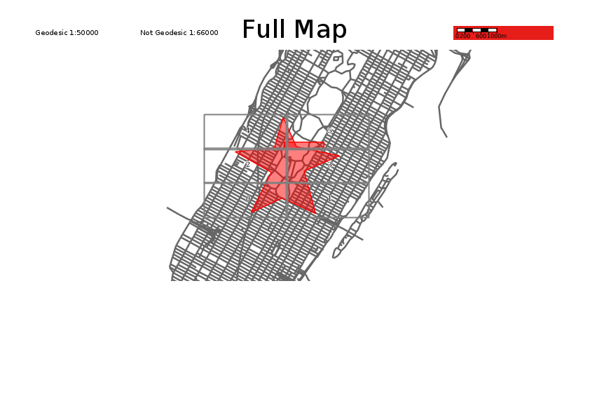
While using getNearestScale for geodetic projection with dpi different than PDF_DPI in paging i noticed that the number of folio generated is wrong. The error comes from the use of...
in CreateMapPagesProcessor, when a map doesn't have an Aoi and the attribut "MapBounds" is zoomToFeatures we should use the bounds of the features as Aoi. Fixed in #620