LT-GEE
 LT-GEE copied to clipboard
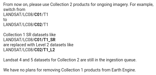
Fix deprecated landsat collection
Hey, I was just working with the LT-GEE API and I noticed the Landsat collection being used is deprecated. I don't have a deep understanding of all the inner workings of the API - so please let me know if it isn't possible or a good idea to switch to the new collection.
The API gives a warning, pointing here:
- https://developers.google.com/earth-engine/guides/landsat#landsat-collection-structure
and other mentions of this collection being deprecated:
- https://developers.google.com/earth-engine/datasets/catalog/landsat
- https://www.usgs.gov/landsat-missions/landsat-collection-1
and from the user group here (Jan 3 2022):
As far as I can tell, L7, L8 Collection 2 have been fully ingested in Earth Engine. Not sure about L5.
Here's a script I used to quickly compare the two collections: https://code.earthengine.google.com/31b105327aa3e1a9f0dce85f9bad7bb6
From my understanding of the LT-GEE API, we'd need to apply the scaling factors given in the example script "Examples/Datasets/LANDSAT_LC08_C02_T1_L2" https://code.earthengine.google.com/638c03d87892e6ab853cd855fab44923
I'm not sure how this interacts with the Roy et al. harmonization though. So it's definitely not a one single line of code change, but I thought I'd open this to put it out there.
Thank you!
Hi Alec, thanks for bringing this up!
I've been updating some other scripts and wanted to share a nice function for scaling and masking L8 SR C2. It would have to be modified slightly to work generically for L5, L7, L8.
function prepSrL8(image) {
  // Develop masks for unwanted pixels (fill, cloud, cloud shadow).
  var qaMask = image.select('QA_PIXEL').bitwiseAnd(parseInt('11111', 2)).eq(0);
  var saturationMask = image.select('QA_RADSAT').eq(0);

  // Apply the scaling factors to the appropriate bands.
  var getFactorImg = function(factorNames) {
    var factorList = image.toDictionary().select(factorNames).values();
    return ee.Image.constant(factorList);
  };
  var scaleImg = getFactorImg([
    'REFLECTANCE_MULT_BAND_.|TEMPERATURE_MULT_BAND_ST_B10']);
  var offsetImg = getFactorImg([
    'REFLECTANCE_ADD_BAND_.|TEMPERATURE_ADD_BAND_ST_B10']);
  var scaled = image.select('SR_B.|ST_B10').multiply(scaleImg).add(offsetImg);

  // Replace original bands with scaled bands and apply masks.
  return image.addBands(scaled, null, true)
    .updateMask(qaMask).updateMask(saturationMask);
}
I don't know what to do about the Roy correction. I think some tests need to be done to see the effect. I believe the coefficients were produced from pre-collection data. I assume that there have been improvements and steps toward aligning the data in C1 and further in C2. Anecdotally, I have seen the correction make harmonization worse, so I'm a little hesitant to continue using them without knowing more.
@jdbcode Will the C1 collection stop working in the near future? I will also need to update the Landsat timelapse functions in geemap to use C2.
@giswqs C1 will most likely be available through 2022. As soon as we know more definitively, we'll get notices out about the cutoff date.
Thanks Justin! That's good to know. And thank you for the prep L8 function. I'll take a look around and see if there's any newer references for harmonization of the new collection. And let us know if you come across anything.
The module was updated in March 2022 to use Landsat Collection 2. See https://code.earthengine.google.com/?scriptPath=users%2Femaprlab%2Fpublic%3AModules%2FLandTrendr.js to verify.