geocompr
 geocompr copied to clipboard
Geocomputation with R: an open source book
Geocomputation with R
![]()

![]()


Introduction
This repository hosts the code underlying Geocomputation with R, a book by Robin Lovelace, Jakub Nowosad, and Jannes Muenchow. If you find the contents useful, please cite it as follows:
Lovelace, Robin, Jakub Nowosad and Jannes Muenchow (2019). Geocomputation with R. The R Series. CRC Press.
The first version of the book has been published by CRC Press in the R Series and can be viewed online at bookdown.org. Read the latest version at geocompr.robinlovelace.net.
Note: we are actively working on the Second Edition 🏗
Since commencing work on the Second Edition in September 2021 much has changed, including:
- Replacement of
rasterwithterrain Chapters 1 to 7 (see commits related to this update here) - Update of Chapter 7 to include mention alternative ways or reading-in OSM data in #656
- Refactor build settings so the book builds on Docker images in the geocompr/docker repo
- Improve the experience of using the book in Binder (ideal for trying out the code before installing or updating the necessary R packages), as documented in issue #691 (thanks to yuvipanda)
- Improved communication of binary spatial predicates in Chapter 4 (see #675)
- New section on the links between subsetting and clipping (see #698) in Chapter 5
- New section on the dimensionally extended 9 intersection model (DE-9IM)
- New chapter on raster-vector interactions split out from Chapter 5
- New section on the sfheaders package
- New section in Chapter 2 on spherical geometry engines and the s2 package
- Replacement of code based on the old mlr package with code based on the new mlr3 package, as described in a huge pull request and popular tweet
See https://github.com/Robinlovelace/geocompr/compare/1.9…main for a continuously updated summary of the changes to date. At the time of writing (April 2022) there have been more than 10k lines of code/prose added, lots of refactoring!

Contributions at this stage are very welcome.
Contributing
We encourage contributions on any part of the book, including:
- improvements to the text, e.g. clarifying unclear sentences, fixing typos (see guidance from Yihui Xie);
- changes to the code, e.g. to do things in a more efficient way;
- suggestions on content (see the project’s issue tracker);
- improvements to and alternative approaches in the Geocompr solutions booklet hosted at geocompr.github.io/solutions (see a blog post on how to update solutions in files such as _01-ex.Rmd here)
See our-style.md for the book’s style.
Many thanks to all contributors to the book so far via GitHub (this list will update automatically): prosoitos, florisvdh, katygregg, rsbivand, iod-ine, KiranmayiV, defuneste, zmbc, erstearns, FlorentBedecarratsNM, dcooley, marcosci, MikeJohnPage, eyesofbambi, nickbearman, tyluRp, giocomai, KHwong12, LaurieLBaker, MarHer90, mdsumner, pat-s, darrellcarvalho, e-clin, gisma, ateucher, annakrystalli, kant, gavinsimpson, Himanshuteli, yutannihilation, jimr1603, jbixon13, olyerickson, yvkschaefer, katiejolly, kwhkim, layik, mpaulacaldas, mtennekes, mvl22, ganes1410, richfitz, wdearden, yihui, chihinl, cshancock, ec-nebi, gregor-d, jasongrahn, p-kono, pokyah, schuetzingit, sdesabbata, tim-salabim, tszberkowitz.
During the project we aim to contribute ‘upstream’ to the packages that
make geocomputation with R possible. This impact is recorded in
our-impact.csv.
Reproducing the book
To ease reproducibility, we created the geocompkg package. Installing
it from GitHub will install all the R packages needed build the book
(you will need a computer with necessary system
dependencies and the
remotes package installed):
install.packages("remotes")
# To reproduce the first Part (chapters 1 to 8):
remotes::install_github("geocompr/geocompkg")

# During development work on the 2nd edition you may also need dev versions of
# other packages to build the book, e.g.:
remotes::install_github("mtennekes/tmap")
Running the commands above should install the packages needed to run the first part of the book (chapters 1 to 8). To install and build the book in its entirety, run the following command (which installs additional ‘Suggests’ packages, this may take some time to run!):
# To reproduce all chapters (install lots of packages, may take some time!)
remotes::install_github("geocompr/geocompkg", dependencies = TRUE)
You need a recent version of the GDAL, GEOS, PROJ and udunits libraries installed for this to work on Mac and Linux. See the sf package’s README for information on that.
Once the dependencies have been installed you should be able to build and view a local version the book with:
bookdown::render_book("index.Rmd") # to build the book
browseURL("_book/index.html") # to view it
Geocompr in binder
For many people the quickest way to get started with Geocomputation with R is in your web browser via Binder. To see an interactive RStudio Server instance click on the following button, which will open mybinder.org with an R installation that has all the dependencies needed to reproduce the book:
![]()
You can also have a play with the repo in RStudio Cloud by clicking on this link (requires log-in):
Geocomputation with R in a Docker container
To ease reproducibility we have made Docker images available, at geocompr/geocompr on DockerHub. These images allow you to explore Geocomputation with R in a virtual machine that has up-to-date dependencies.
After you have installed docker and set-it up on your computer you can start RStudio Server without a password (see the Rocker project for info on how to add a password and other security steps for public-facing servers):
docker run -p 8787:8787 -e DISABLE_AUTH=TRUE geocompr/geocompr
If it worked you should be able to open-up RStudio server by opening a browser and navigating to http://localhost:8787/ resulting in an up-to-date version of R and RStudio running in a container.
Start a plain R session running:
docker run -it geocompr/geocompr R
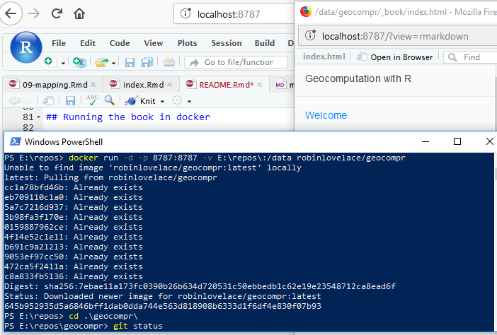
If you see something like this after following the steps above, congratulations: it worked! See github.com/rocker-org for more info.
If you want to call QGIS from R, you can use the qgis tag, by running
the following command for example (which also shows how to set a
password and use a different port on localhost):
docker run -d -p 8799:8787 -e USERID=$UID -e PASSWORD=strongpass -v $(pwd):/home/rstudio/geocompr robinlovelace/geocompr:qgis
From this point to build the book you can open projects in the
geocompr directory from the project box in the top-right hand corner,
and knit index.Rmd with the little knit button above the the RStudio
script panel (Ctl+Shift+B should do the same job).
See the geocompr/docker repo for details, including how to share volumes between your computer and the Docker image, for using geographic R packages on your own data and for information on available tags.
Reproducing this README
To reduce the book’s dependencies, scripts to be run infrequently to generate input for the book are run on creation of this README.
The additional packages required for this can be installed as follows:
source("code/extra-pkgs.R")
With these additional dependencies installed, you should be able to run the following scripts, which create content for the book, that we’ve removed from the main book build to reduce package dependencies and the book’s build time:
source("code/01-cranlogs.R")
source("code/sf-revdep.R")
source("code/09-urban-animation.R")
source("code/09-map-pkgs.R")
Note: the .Rproj file is configured to build a website not a single
page. To reproduce this
README
use the following command:
rmarkdown::render("README.Rmd", output_format = "github_document", output_file = "README.md")
Citations
To cite packages used in this book we use code from Efficient R Programming:
# geocompkg:::generate_citations()
This generates .bib and .csv files containing the packages. The current of packages used can be read-in as follows:
pkg_df = readr::read_csv("extdata/package_list.csv")
Other citations are stored online using Zotero.
If you would like to add to the references, please use Zotero, join the open group add your citation to the open geocompr library.
We use the following citation key format:
[auth:lower]_[veryshorttitle:lower]_[year]
This can be set from inside Zotero desktop with the Better Bibtex plugin
installed (see
github.com/retorquere/zotero-better-bibtex)
by selecting the following menu options (with the shortcut Alt+E
followed by N), and as illustrated in the figure below:
Edit > Preferences > Better Bibtex

Zotero settings: these are useful if you want to add references.
We use Zotero because it is a powerful open source reference manager that integrates well with the citr package. As described in the GitHub repo Robinlovelace/rmarkdown-citr-demo.
References
# remotes::install_github("gadenbuie/regexplain")
# regexplain::regexplain_file("extdata/package_list.csv")
pattern = " \\[[^\\}]*\\]" # perl=TRUE
pkg_df$Title = gsub(pattern = pattern, replacement = "", x = pkg_df$Title, perl = TRUE)
knitr::kable(pkg_df)
| Name | Title | version |
|---|---|---|
| bookdown | Authoring Books and Technical Documents with R Markdown | 0.7 |
| cartogram | Create Cartograms with R | 0.1.0 |
| dismo | Species Distribution Modeling | 1.1.4 |
| geosphere | Spherical Trigonometry | 1.5.7 |
| ggmap | Spatial Visualization with ggplot2 | 2.6.1 |
| ggplot2 | Create Elegant Data Visualisations Using the Grammar of Graphics | 3.0.0.9000 |
| gstat | Spatial and Spatio-Temporal Geostatistical Modelling, Prediction | 1.1.6 |
| historydata | Datasets for Historians | 0.2.9001 |
| htmlwidgets | HTML Widgets for R | 1.2 |
| kableExtra | Construct Complex Table with ‘kable’ and Pipe Syntax | 0.9.0 |
| kernlab | Kernel-Based Machine Learning Lab | 0.9.26 |
| knitr | A General-Purpose Package for Dynamic Report Generation in R | 1.20 |
| latticeExtra | Extra Graphical Utilities Based on Lattice | 0.6.28 |
| leaflet | Create Interactive Web Maps with the JavaScript ‘Leaflet’ | 2.0.1 |
| link2GI | Linking Geographic Information Systems, Remote Sensing and Other | 0.3.0 |
| lwgeom | Bindings to Selected ‘liblwgeom’ Functions for Simple Features | 0.1.4 |
| mapview | Interactive Viewing of Spatial Data in R | 2.4.0 |
| microbenchmark | Accurate Timing Functions | 1.4.4 |
| mlr | Machine Learning in R | 2.12.1 |
| osmdata | Import ‘OpenStreetMap’ Data as Simple Features or Spatial | 0.0.7 |
| pROC | Display and Analyze ROC Curves | 1.12.1 |
| ranger | A Fast Implementation of Random Forests | 0.10.1 |
| raster | Geographic Data Analysis and Modeling | 2.6.7 |
| rcartocolor | ‘CARTOColors’ Palettes | 0.0.22 |
| rgdal | Bindings for the ‘Geospatial’ Data Abstraction Library | 1.3.3 |
| rgeos | Interface to Geometry Engine - Open Source (‘GEOS’) | 0.3.28 |
| rgrass7 | Interface Between GRASS 7 Geographical Information System and R | 0.1.10 |
| rmapshaper | Client for ‘mapshaper’ for ‘Geospatial’ Operations | 0.4.0 |
| rmarkdown | Dynamic Documents for R | 1.10 |
| rnaturalearth | World Map Data from Natural Earth | 0.2.0 |
| rnaturalearthdata | World Vector Map Data from Natural Earth Used in ‘rnaturalearth’ | 0.1.0 |
| RPostgreSQL | R Interface to the ‘PostgreSQL’ Database System | 0.6.2 |
| RQGIS | Integrating R with QGIS | 1.0.3 |
| RSAGA | SAGA Geoprocessing and Terrain Analysis | 1.1.0 |
| sf | Simple Features for R | 0.6.3 |
| sp | Classes and Methods for Spatial Data | 1.3.1 |
| spData | Datasets for Spatial Analysis | 0.2.9.0 |
| spDataLarge | Large datasets for spatial analysis | 0.2.7.0 |
| stplanr | Sustainable Transport Planning | 0.2.4.9000 |
| tabularaster | Tidy Tools for ‘Raster’ Data | 0.5.0 |
| tidyverse | Easily Install and Load the ‘Tidyverse’ | 1.2.1 |
| tmap | Thematic Maps | 2.0.1 |
| tmaptools | Thematic Map Tools | 2.0.1 |
| tree | Classification and Regression Trees | 1.0.39 |
| vegan | Community Ecology Package | 2.5.2 |