[Pelias] Add codes to admin levels and support for localization and layers.
Hi Jonathan,
We're moving towards using Pelias for geocoding, using the provider you wrote. We would like to use the codes for administrative regions as well, hence my pull request.
Examples to support the change:
Location before adding the admin level code
object(Camptoo\Geocoding\GeocoderLocation) {
	[protected] location => object(Geocoder\Model\Address) {
		[private] coordinates => object(Geocoder\Model\Coordinates) {
			[private] latitude => (float) 51.946443
			[private] longitude => (float) 4.509113
		}
		[private] bounds => object(Geocoder\Model\Bounds) {
			[private] south => (float) 52.332531
			[private] west => (float) 5.149456
			[private] north => (float) 51.64378
			[private] east => (float) 3.786154
		}
		[private] streetNumber => null
		[private] streetName => null
		[private] subLocality => null
		[private] locality => null
		[private] postalCode => null
		[private] adminLevels => object(Geocoder\Model\AdminLevelCollection) {
			[private] adminLevels => [
				(int) 1 => object(Geocoder\Model\AdminLevel) {
					[private] level => (int) 1
					[private] name => 'Zuid-Holland'
					[private] code => null
				},
				(int) 5 => object(Geocoder\Model\AdminLevel) {
					[private] level => (int) 5
					[private] name => 'Netherlands'
					[private] code => null
				}
			]
		}
		[private] country => object(Geocoder\Model\Country) {
			[private] name => 'Netherlands'
			[private] code => 'NLD'
		}
		[private] timezone => null
		[private] providedBy => 'pelias'
	}
}
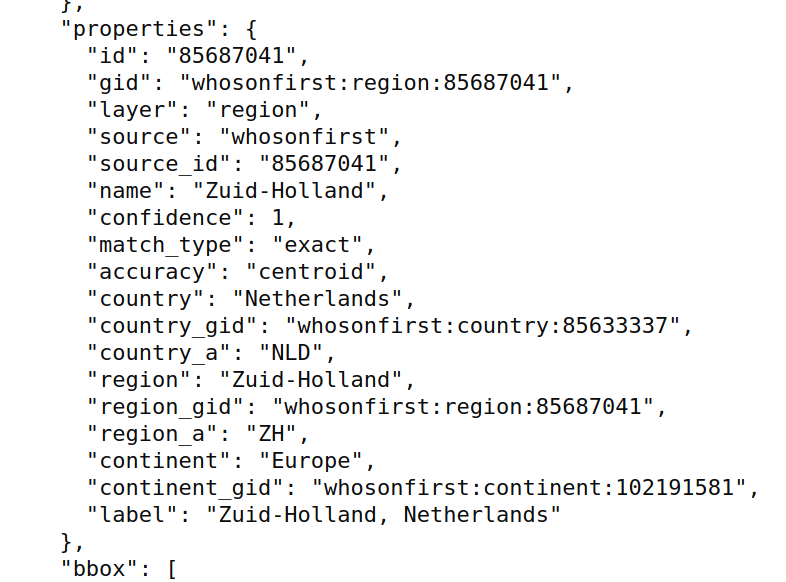
Result from Pelias
Location after adding the admin level code
object(Camptoo\Geocoding\GeocoderLocation) {
	[protected] location => object(Geocoder\Model\Address) {
		[private] coordinates => object(Geocoder\Model\Coordinates) {
			[private] latitude => (float) 51.946443
			[private] longitude => (float) 4.509113
		}
		[private] bounds => object(Geocoder\Model\Bounds) {
			[private] south => (float) 52.332531
			[private] west => (float) 5.149456
			[private] north => (float) 51.64378
			[private] east => (float) 3.786154
		}
		[private] streetNumber => null
		[private] streetName => null
		[private] subLocality => null
		[private] locality => null
		[private] postalCode => null
		[private] adminLevels => object(Geocoder\Model\AdminLevelCollection) {
			[private] adminLevels => [
				(int) 1 => object(Geocoder\Model\AdminLevel) {
					[private] level => (int) 1
					[private] name => 'Zuid-Holland'
					[private] code => 'ZH'
				},
				(int) 5 => object(Geocoder\Model\AdminLevel) {
					[private] level => (int) 5
					[private] name => 'Netherlands'
					[private] code => 'NLD'
				}
			]
		}
		[private] country => object(Geocoder\Model\Country) {
			[private] name => 'Netherlands'
			[private] code => 'NLD'
		}
		[private] timezone => null
		[private] providedBy => 'pelias'
	}
}
Hope you like the addition.
Best regards
Thanks @gbs !
I'll review it ASAP. Could you already make sure the formatting is correct (see https://github.styleci.io/analyses/Yj5KnG) ?
Hi @jbelien,
The formatting is correct now. The build is failing, but I see this is on the master branch as well.
Since we're starting to use Pelias in more features, support for localization and layers was added. Also I improved the tests a bit by checking the query data from the request.