Alternative servers for NASA core imagery
At https://worldwind.earth/#about one can read
WorldWindJava I have alternative servers for NASA core imagery (from worldwind25.arc.nasa.gov/wms) and NASA elevations (from worldwind26.arc.nasa.gov/elev) staged for production should the WorldWind shutdown become a reality. I will make these servers available if needed.
I need them. :) Would it be possible to gain access to the old layers? I would be happy to use them in https://mapton.org/
Patrik, nice work! I'll bet that Bruce (emxsys) will be able to help you!
Bruce mentioned these links regarding alternative servers for imagery and elevation: https://worldwind.earth/elevation-server.html https://worldwind.earth/elevation-data.html
Also check: https://gist.github.com/emxsys/f8c7a8dd5cf0060387ce50aa3f186bac https://gist.github.com/emxsys/e3eac29221eec86d1d42525517acb3ad
It'll be grand to get several sources for this data established, so there is back-up everywhere.
Buona Fortuna!
I have elevation and imagery servers on standby should the WW servers go offline. You are welcome to evaluate them with the following caveats:
- No bulk downloads! These servers are paid for out of my own pocket with no funding. I do not want to incur additional charges for high throughput.
- No service guarantee for up time or availability. Again, these servers are paid for out of my own pocket. They are not production servers and are still under development.
• https://emxsys.net/worldwind25/wms • https://emxsys.net/worldwind26/elev • https://emxsys.net/worldwind27/wms/virtualearth
@trixon I'm happy to see another NetBeans/WorldWind project!
Thank you @PJHogan, I was looking for an existing wms server that I could use. So thank you too @emxsys, for providing them.
I was really happy to see Virtual Earth layers, would it be ok to "bundle" access to them in Mapton? If so, what would you like the attribution to look like?
It's a big relief to know about this WWJ-CE and I wish us all the best, thank you for your efforts!
@trixon It's OK to use my servers in Mapton. Please keep in mind that these servers are still in a development stage and their status could change if/when the future of the NASA servers becomes stable. In other words I may scale back my services to reduce costs when it makes sense to do so.
@emxsys It's working just fine, for now anyway. :)
This "blur" in Virtual Earth above 5000 km altitude and 36 degrees from the poles, is it something new or has it always been like this?
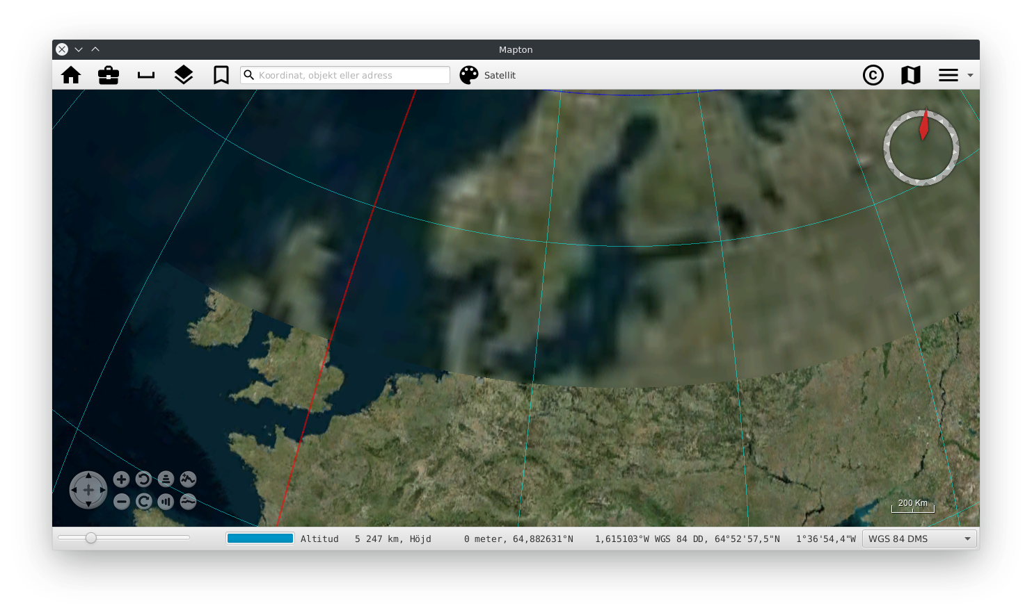
@trixon The "blur" is most likely caused by lower resolution tiles being used instead of the higher resolution tiles. This is abnormal for the area in your screenshot. The source of the low-res tiles needs to be identified, possibly from a cache Suggestions:
- Delete your Bing cache folder (in Wndows: "C:\ProgramData\WorldWindData\Earth\Bing") and see if the problem replicates or disappears.
- If the problem persists, I'll delete the Bing cache on my server and we can repeat step 1.
We can dive deeper into the issue after these tests (I suspect I may need to increase a timeout when accessing Microsoft Bing servers). Meanwhile, I'll fork your app and check it out when I have time.
@emxsys I cleared the cache on two computers, but the "blur" came back. This is also visible in the south, just about on the tip of South America. If you do fork it, have a look at https://mapton.org/for-developers/ for some dependencies not available through maven.
Mapton's cache is located in $HOME/.cache/mapton and since WorldWind is just one of (theoretically) many MapEngines, WMS are loaded programmatically and not in the most WorldWind natural way I guess.
@trixon The "blur" is most likely caused by lower resolution tiles being used instead of the higher resolution tiles. This is abnormal for the area in your screenshot. The source of the low-res tiles needs to be identified, possibly from a cache Suggestions:
- Delete your Bing cache folder (in Wndows: "C:\ProgramData\WorldWindData\Earth\Bing") and see if the problem replicates or disappears.
- If the problem persists, I'll delete the Bing cache on my server and we can repeat step 1.
We can dive deeper into the issue after these tests (I suspect I may need to increase a timeout when accessing Microsoft Bing servers). Meanwhile, I'll fork your app and check it out when I have time.
@emxsys Have you had a chance to delete the cache on the server? One related thing I noticed today is
java.security.cert.CertificateExpiredException: NotAfter: Sun Jul 07 23:10:59 CEST 2019
...
Caused: gov.nasa.worldwind.exception.WWRuntimeException: Exception attempting to parse XML https://emxsys.net/worldwind27/wms/virtualearth?request=GetCapabilities&service=WMS&EXCEPTIONS=application/vnd.ogc.se_xml&REQUEST=GetCapabilities&SERVICE=WMS&VERSION=1.3.0&
And yes, I'm still aware of the "SLA" :), and thankful.