terrain layer
https://github.com/visgl/deck.gl/blob/master/docs/layers/terrain-layer.md
TODO
- [ ] examples of loading various DEMs
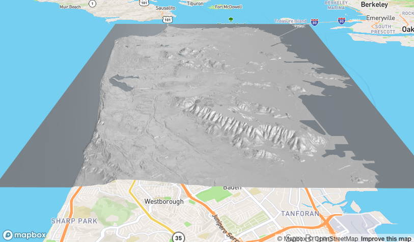
Proof of concept
mapdeck() %>%
  add_terrain()
Hello, I'm trying to use add_terrain but can't to get a terrain file (png) located somewhere else to work, see the example below.
The terrain.png and mask are the same files used in the example document
elevation <- "file:///home/Downloads/terrain.png"
texture <- "file:///home/Downloads/terrain-mask.png"

mapdeck() %>%
  add_terrain(
    , elevation_data = elevation
    , elevation_decoder = c(1,0,0,0)
    , texture = texture
    , bounds = bounds
    , max_error = 1
  )
taking examples from
- https://github.com/visgl/deck.gl/issues/5121
- https://stackoverflow.com/a/33410766/4002530
you need to encode the files. Here's a working example
library(RCurl)
elevation <- normalizePath( '~/Downloads/terrain.png')
texture <- normalizePath('~/Downloads/terrain-mask.png')

txt <- base64Encode(readBin(elevation, "raw", file.info(elevation)[1, "size"]), "txt")
elevation_data <- sprintf("data:image/png;base64,%s", txt)

txt <- base64Encode(readBin(texture, "raw", file.info(texture)[1, "size"]), "txt")
texture_data <- sprintf("data:image/png;base64,%s", txt)

## image = 'data:image/jpeg;base64,'+ str(base64.b64encode(open("/path/to/file", "rb").read()).decode('utf-8'))
bounds <- c(-122.5233, 37.6493, -122.3566, 37.8159)


library(mapdeck)
set_token(secret::get_secret("MAPBOX"))

mapdeck() %>%
	add_terrain(
		, elevation_data = elevation_data
		, elevation_decoder = c(1,0,0,0)
		, texture = texture_data
		, bounds = bounds
		, max_error = 1
	)
you could probably simplify the string encoding with base64enc::base64encode("file.png")
That worked, but I'm still having issues trying to load in a different elevation png. I'm trying to make a bathymetric terrain using the marmap package like so:
library(marmap)

b <- getNOAA.bathy(lon1 = -74.24547803104537, lon2 =  -73.27730792856238, lat1=40.291108390496284,
                   lat2 = 40.68746589140695, resolution = 0.1)

r <- as.raster(b)
png(file = "myplot.png", bg = "transparent")
raster::plot(r, maxpixels=ncell(r), col=hcl.colors(24, palette = "Blues 2"),
             axes=FALSE, box=FALSE, legend=FALSE)
dev.off()
This saves a png. But then I try and use this in add_terrain() :
elevation <- normalizePath( "myplot.png")
texture = normalizePath( "myplot.png")

elevation_data <-  sprintf("data:image/png;base64,%s", base64enc::base64encode(elevation))
texture_data <- sprintf("data:image/png;base64,%s", base64enc::base64encode(texture))

bounds <- c(r@extent@xmin, r@extent@ymin, r@extent@xmax, r@extent@ymax)

mapdeck() %>%
  add_terrain(
    , elevation_data = elevation_data
    , elevation_decoder = c(1,0,0,0)
    , texture = texture_data
    , bounds = bounds
    , max_error = 1
  )
It doesn't render anything, am I missing something?
Alternatively, is there a way to load in base service layers from mapbox? I found this one: https://docs.mapbox.com/data/tilesets/reference/mapbox-bathymetry-v2/
But I'm not sure how to use that.