WGS84 gcrs vs. pcrs
@joanma747 We are implementing a <layer>.extent and potentially a (similar)
My question / this issue is: should the pcrs coordinates sometimes "wrap", and should the gcrs coordinates never "wrap"?
I believe it might be beneficial to have the default behaviour of the pcrs be to not wrap, since we could then use the pcrs coordinate system for non-geographic content i.e. star maps or microchip electron microscopy etc.
But my impression is that the gcrs should never wrap, because spherical coordinates outside of the defined range of a sphere is nonsensical. On the other hand, would it be reasonable to be able to wrap the pcrs coordinates, subject to some parameter or layer metadata?
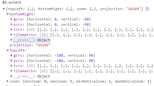
The draft property model looks like this for a WGS84 layer (with a conventional earth-related extent):
If the pcrs coordinates were allowed to not wrap, they could extend out to +/- "infinity" in both directions, while if the gcrs coordinates were wrapped they would be not equal to the pcrs coordinates outside the spherical coordinate limits i.e. would be greater or less than their gcrs equivalent (sorry I don't have a graphic for this scenario at the moment).
Addendum: In your view, what should the axis names in the pcrs be?